Friday, July 11, 2008

Yukon Ho!

And now for the latest adventures of Molly Malone, the dirtpatch anthropologist...

That's right folks, I've headed to the northwest corner of Canada to live out the dream Calvin & Hobbes inspired in me so long ago.

I'm here working as a research assistant to Professor Patrick Moore of the University of British Columbia, where I am currently a PhD student in anthropology. Pat is doing linguistic research on Kaska, a native language spoken in parts of the Yukon and BC, mostly by people in their 50s and older (referred to as elders). I haven't been on the water as much as the other Expeditionettes, but I am getting to learn a lot about how people have lived off the land for the past few thousand years.

The photo up top is of the sign at the BC/YT border: "Welcome to North of 60." When I first saw it, I thought it said "Welcome to North of Go," in reference to Monopoly. I was wrong.

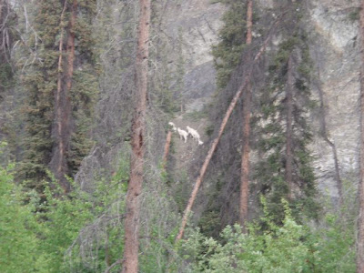
This is some typical southern Yukon scenery. The white trees are poplars, the other trees include spruce and jack pine. There are berries all over the place: strawberries, soap berries, bear berries. A grizzly bear is probably about to jump out and eat you.

This is me at work with Kassua, my 3 year-old half-Kaska, half-German intern. My jobs include running the video camera while elders tell stories, setting up really fancy voice recording equipment (Marantz, anyone?), taking notes in a language I neither speak nor understand, fetching lunch meat, brewing countless pots of tea, and driving the elders wherever they need to go. I make it sound tedious for humor's sake, but it's actually a really awesome experience.

These are my new moccasins made from moose hide and beaver fur (don't tell PETA). They were sewn by Kaska elder Minnie Caesar. Kaska women like Minnie tan their own hides and do intricate bead work on things like moccasins, vests, and headbands. They make a good living doing it, too, since tourists are willing to pay top dollar for Indian-made items.

This is what the back of your car looks like after driving for 400km on the Robert Campbell Highway--a road that is only paved for about 40km--in the rain. Check out the little gold miner on the left--killer facial hair, eh? I also like his "toque." Words of advice for driving in the Yukon: if you don't like mud, stay on the Alaska Highway.

This is the sign at the entrance to Lower Post, a Kaska community right across the border in BC. I've been driving here almost every day to bring some elders up to where we are working in Watson Lake. The top of the sign is written in Kaska.

Watson Lake has a signpost forest. What is that, you say? Obviously it is a forest of beams where you nail up a sign you stole from home. And I found one from Asheville.

This is what you have to drive up here, so you can bulldoze the grizzly bears before they kill you. Just kidding--they'd kill you anyway! Yukoners just love big machines. The better to extract all the minerals with, my dear...

And how do you transport all those minerals so they can sail to China? In a muffin truck, of course.

Fireweed!

On Monday we head to Frances Lake for some more research, and the elders are all bringing their boats and their guns. Stay tuned for tales of fishnets and mooseheads...


Wednesday, July 09, 2008

Fourth of July Celebration- Honolulu Creek and Chulitna River


Fourth of July is an important holiday for the Dirtpatch.  This 4th represented two years since our Honduras adventure, which ended with an emergency flight home and a cancer diagnosis.  Last year, Stacy and I made our way down the Middle Fork of the Salmon river on the 4th of July.  A few years before, Stacy and I had gotten lost in the Olympic National Park on the 4th of July.  And a few years before that we were engaged in some major firework wars at the Ocoee River on the same holiday.  It is becoming a tradition to have some sort of adventure/ celebration on the 4th every year.  This year was no exception, except that I was on my own for this one.  I am sure that the rest of the DP was celebrating somewhere as well.


For this year's celebration, I got to fly into Goat Lake with Scott and Allen Warren.  Goat Lake is an incredibly beautiful and pristine mountain lake near Denali National Park.  A couple of photographers from SELF magazine were also flown in to take some pics.  They are doing a story on cancer survivors and I am one of the survivors in the article.  We spent a day shooting pictures, hiking, and fishing, and then paddled out via the clear waters of Honolulu Creek.  


Scott making Thai food at Goat Lake
Goat Lake was one of the most beautiful places I have been, and the weather couldn't have been better.   It was a great feeling to be flown into this place, knowing that the only way to get out of there was by kayak, plane, or a really long hike.  A few Carribou decided to join us for dinner that night on the other side of the lake.  We also spent some time catching Dolly Bartons (Not sure if that is spelled right, sounds like Dolly Parton with a 'B'), which became dinner on night two.


Beginning a kayaking trip with photographers was a unique experience.  They were really nice guys, straight out of LA, and we really enjoyed camping with them for the night.  They had been photographing several other cancer survivor athletes, and it was great to hear about them. 

SELF rapid on the creek that feeds out of the lake and meets with Honolulu Creek

After the photos were taken, Ray came back and picked up the photographers.  Allen and Scott and I decided to take a little hike.  We pointed to the top of one of the peaks around us and decided to go there.  It turned out to be a pretty long, intense hike, and the views were spectacular.  With the weather being as clear as it was, we were able to see Denali (Mt. McKinnley) from the top really clearly, although 'the Great One' didn't show up very well on camera.  

The boys taking a short break and checking out the view

The view from the top: my feet and Denali, which doesn't show up that well on camera

5 hours later, we were back at Goat Lake.  Allen fished for our dinner, catching a few Dollies which we through in with some couscous- oishi (delicious)!  The next morning we managed to make it down the small creek and eventually into Honolulu Creek.

packin' it up

Me and Goat Mountain in the Background

Honolulu Creek was a really nice class IV creek with amazing views.  It was 12 miles back out to the road from the lake.  It flowed into the Chulitna river, which became our next river trip.  

Scott on Honolulu Creek


Me on Honolulu Creek
The Chulitna rafting trip was the greatest fishing trip I have ever been on.  The river was beautiful and the company was fantastic.  Unlike the Charlie, the weather was bright and sunny most of the time.

Allen's raft near the put-in
We didn't catch many fish the first day, but found a perfect camp spot to celebrate the 4th.  We were up bright and early the next morning and floated down to the sweet fishing spot.  The place is called Spink Creek, and it is a clear creek that flows into the silty Chulitna.  It was big and slow moving and an ideal place for Kings.  To get here, you have to know where the creek is, and make a big ferry move to avoid the logs and enter the mouth of the creek.

Newman caught one before we decided to stop for dinner.  As soon as dinner was over, the skies let loose with a huge hail storm.  We all took cover in our tents and eventually all fell asleep.  

The next morning at 5 am, Scott and I snuck out of the tents, and took the raft out to fish.  It was the best fishing I've ever been a part of. :)  We pulled in four Kings, two each before we stopped to wake up the rest of the group.  

Catching my first King!  Fish on!!!

As soon as everyone woke up and saw the fish, they piled into the raft and took off in pursuit of their Kings.

The Chulitna Group: Newman, Tera, Allen, Me Scott, Dale, Char, and Ben

Not only was the weather perfect that day, so was the fishing, and so was the view.  We were able to get a clear view of Denali all the way to the take-out.

Denali, also known as Mt. McKinnley, means Great One.  
Real Alaskans don't call it Mt. McKinnley, since president McKinnley never even came up to Alaska.

Fourth of July has become a celebration of life and adventure for the DirtPatch.  Life is short, but it is wide, and it is made to be packed with experiences.  Flying through the air over the beautiful mountains, living it up next to a pristine mountain lake, watching the carribou, hiking to the top of the mountains, kayaking with the boys, floating and fishing the Chulitna, and seeing the powerful snow covered Denali, I felt ever so grateful for the life that I have, and the gifts that I have been given, and independence from the threat of cancer.  I felt really free and really blessed.

Newman caught the big fish that morning.
Mine's the big one on the ground!  :)

Charlie River Fishing Trip


The third week of June, we rafted down the beautiful Charlie River.   It felt good to be on that river, even as the wind whispered past my ears, trying to cut through my jacket, stinging my bear toes and fingers.  

To access this run, we had to hire a plane to take us to the put in.  The first member of the group to arrive at the put in had to deal with a curious grizzly until the rest of us got there.  The river was pretty technical at first for the rafts and then gained more volume as we floated out further out of the mountains.  

Here is our crew...
Allen, Jason, Matt, Mindy, Dale, Newman, me and Scottie
Scott's Dad and his friend, Rusty, flew their float planes in and picked up Matt and Mindy to take them back to the airport so they could fly home to Utah.  It was pretty cool to be out there for 3 days and then see two float planes land on the river.  Not a bad trip for Matt and Mindy, too, to fly into and out of a river in Alaska during their vacation.  

It was pretty rainy on 3 of the 5 days we were out.  The fishing could have been better, but we managed to catch 2 or 3 pike and a she-fish.  The trip itself was beautiful and our group was really entertaining.  At one point, Scott and I stopped and checked out some wild sheep that were pretty close to the river.  They seemed so much bigger when they were closer.  As we watched them we began to hear sounds of thunder in the distance shortly joined by the sound of another cold summer shower, which began to fall from the sky all around us.


We saw several bald eagles and I did catch 5 little greylings, which I threw back since they were too small to eat.


 We did a hike one morning and were able to get a good birds-eye view of the river.  Here is a picture of me with Newman and Dale, two of my favorite Alaskans.

The Charlie fed into the Yukon river, which the rest of the gang (minus Matt and Mindy) floated out until we reached the city of Circle, AK.  Back during the 'golden' age of Alaska, this town was a bustling hub for prospectors.  There was a theatre and about 12 saloons there, now there are only a few buildings, and not much else.  It was really cool to see that town.  There were some hotsprings nearby that we went to and then we headed back to Fairbanks.

Here are some pics of the Yukon river:


living in a van down by the river


Scottie and I have been in Alaska for a few weeks now.  This place is amazing.  After arriving in Fairbanks, we fixed up Scott's van and took it out on the open road.  We drove through Denali around 11pm on the 5th of June and the sun's golden glow was still shining, illuminating the earth, the clouds, and the snowcapped peaks which surrounded us.  It was like that all night until the sun decided to rise out of it's colorful repose and rise up into the sky the next day.
We first ran the Nanana river, camped at Troublesome Creek, and did some fishing.  We didn't catch anything, but you could see Denali (aka Mt. McKinnely for non-Alaskan people) from our fishing spot and it was gorgeous.  Scott and I headed south afterwords, took a nice hike up the little Susitna river.  The hike turned into a breath taking run towards a glacier under imposing snowcapped mountains.  Afterwards we put on the little Sue and it ended up being a really fun, continuous class IV creek.  Sort of like Big Creek back home.  We met a nice couple who took some pictures and emailed them to me...  here is one of them.

here is another...
and one more...


After that, we paddled 6 mile creek (no photos of that one, sorry) and stayed with Beer Can Dan in Anchorage.  Then we picked up Scott's friend, Matt, and paddled Ship creek.  We had a small brush with the law there, and got some warning tickets for being on military property (no photos again, sorry).  We hiked into Ingram Creek one day, but no one had been in it yet this year and it looked pretty snowy.  We were worried about the logs and ice bridges that may still be in the river, so we are gonna save that one for later this summer.  Maybe when Stacy gets in town.  We paddled Canyon Creek and Bird Creek as well.  The water up here is really cold, but the weather is pretty nice.
Here is a picture of the falls at Bird Creek.
Here is a picture of our hike up the little Sue


Here is one of the hike into Ingram Creek


After that, we went to the Charlie River.  That'll be the next post.

Sunday, June 29, 2008

California Update

photo: robin betz

This June I headed back to California with a couple of goals in mind. Even after having logged two runs down the Middle Fork of the Kings on past summer trips, there were still several California Classics that I had never experienced. The Kaweah River, Dinkey Creek, Fantasy Falls, West Cherry.... and more. You hear from everyone that Dinkey Creek should not be missed, that Fantasy Falls is an incredible adventure, and that West Cherry is almost as badass as Upper Cherry. Let's just say I got my birthday wish - and enjoyed an incredible line-up of classics! Stay tuned to Liquid Logic Ladies Lounge , Astral Buoyancy Gallery, and Shred Ready Beatdown for the rest of the story.

Thursday, August 16, 2007

Boof Against the Odds slides back into home

I finally have arrived back in Asheville after an incredible summer of boofing against the odds. Before BOA was officially kicked off in June, I was able to warm up by kayaking in California, North Carolina and Colorado. I paddled the Nordheimer section of the Salmon river and South Silver in California, then back to Old Faithful, the Green River in North Carolina, and then back west to Oh Be Joyful in Colorado and competed in the Homesteak Creek Race (3rd place). This was all to get in shape for the Boof Against the Odds fundraiser, where Stacy Heer, Robin Betz and myself were trying to paddle 300 miles in the months of June and July (61 days).

So here is the breakdown of the miles we were able to accomplish:


Colorado

June 1- Day one of Boof Against the Odds!
Tommy, Scott and I kicked off BAO by paddling 8.1 miles, putting on at the Barrell Springs section of the Colorado and following it down to Tommy's house.
Day 2, I had come down with some kind of bug already and decided not to get into the water. I figured if I rested, it would go away and I would get better faster and paddle more whitewater.
Day 3, I paddled the same section of the Colorado with my brother, logging another 8.1 miles.

Then I left for California! So far I had logged 16.2 miles, driving on day 4 and 5 to pick up Robin on Day 6


California

Day 6, I picked up Robin in Reno at the airport and we head to the Truckee River. We paddled there with loaded boats to get in some kind of practice before paddling the hooha with them. We logged 2 miles on the river and then hiked 2 miles through the urban jungle back to the dirtpatch mobile. This is when I decided that hiking with a kayak should count as miles because it is actually much harder to carry your kayak than for your kayak to carry you.
hey, it's our fundraiser, we get to make the rules. :) So, here we logged 4 miles.

We drove to meet Jason Hale on day 7 and went hiking with him up to Donner Summit, waiting to see if the Middle Kings was going to run and if the boys were going to meet us there to run it. On day 8 we drove to run Cherry Creek of the Tuolomne (Cherry Proper), which I think we ran on day 9, giving us 9 more miles.

We drove to set shuttle for the Middle Fork of the Kings adventure on day 10, and began hiking on day 11. Team Idaho, Team Sketch and Team Vermont were with Tdub and ourselves (the dirtpatch) on that part of the journey. We paddled on days 12-14 before I had an epic swim/hiking/camping adventure on day 15. I hitchhiked back to meet the rest of the crew (who paddled the Garlic Falls section of the Kings) on day 16. Before driving back to Lake Tahoe to stay with our girl, Molly, we had logged 29 miles of kayaking and 12 miles of hiking, bringing us to 54 miles in California. So, now we had a total of 70.2 miles!

Oregon/Washington
On day 21 I met Stacy in Hood River Oregon. We decided to do an overnighter on the Clackamus River and logged another 29 miles there on days 22-23.

The next few days we spent around Hood River. About day 24, Stacy and I met up with Lana and ran the Green Truss logging 4.9 miles. Stacy got lit up by some bees that day, taking 15 stings to the face and ears. Day 25 I paddled the Truss again with Lana, Heather and Christie G (ladies' trip!), then went to run the Little White that afternoon with Keel, Jay, Ian and Evan logging 5.5 on the Ldub and 4.9 on the Truss. Day 26, I spent with the ladies on the Lower Wind River logging 5 miles and running some water falls that were really pretty.

Day 27, I paddled the Ldub again with Matt Gaudette and Chris Jones. And finally, on the last day in Hood River (day 28) , we paddled down one last time on the Ldub with Matt, Jay, Keel, Ryan, Boone, and Russell. That was a really fun group and I finally fired up Spirit with Jay and Keel setting safety from below. That was 11 miles for those two days.

So all together in Hood River, we logged 55.4 miles, totaling 125.6 miles for the entire trip so far!

I drove to Boise to meet up with Stacy on day 29, and spent day 30-32 in Boise with Stacy and Collin.

Idaho

On July 3rd, day 33, Stacy and I put in on Marsh Creek, which feeds into the Middle Fork of the Salmon River. We had a great time logging 118 miles on that creek and the rest of the MFS during the next few days, taking out on July 6th.

On day 37 we drove to the North Fork of the Payette, running the top five miles on day 38. It took us 2 more days to run 2 miles of the middle 5 and all of the bottom five due to lots of scouting and one boat going down in a blaze of glory. (logging 12 miles)

On day 41, we paddled the entire South Fork of the Payette from around mile marker 30 to the confluence with the North Fork. The river winds away from the road, and after looking at the information on AW's website, I believe we paddled about 35 miles.

Therefore in Idaho, we totaled 165 miles. Bringing us up to a total of 290.6 miles! Stacy and I then decided to head back to Colorado to finish the Boof against the Odds Challenge there.

Back in Colorado!
Stacy and I had the opportunity to paddle with the wonderful people from Pike's Peak Whitewater Club on day 45, after spending some Q-T with my nephews. We paddled the Arkansas from Pinnacle Rock through the Royal Gorge to get a total of about 19 miles.

On days 50- 56 I had the opportunity to spend a week with First Descents outside of Vail, Colorado. During that week, we paddled Shoshone twice (2x2=4 miles) , a section of the Colorado near the Dotsero exit on I-70 (about 5 miles), the section from the take-out of Shoshone to Glenwood Springs (about 5 miles), and the Pumphouse section of the Eagle River (about 5 miles). We racked up 19 miles that week! Giving us 38 miles for this trip to Colorado and brining the total up to 328.6 miles!


Alaska

Boof Against the Odds was finished in Alaska on days 60 & 61 on the Copper River in Alaska! It was so beautiful and a perfect way to end this unbelievable summer. There was no way to tell exactly how many miles we did those first two days of the five day trip, but I would guess it was about 35 miles. 10 the first night and probably about 25 the next day. Bringing the grand total of Boof Against the Odds first summer challenge to.... 363.6 miles!

Wednesday, August 15, 2007

Alaska!


The final days of Boof Against the Odds were spent in Alaska of all places. I flew there the day after I left First Descents. Alaska is one of the most beautiful places I have ever been. Scott Dillard, who I paddled with on the first days of the fundraiser lives in Fairbanks and I finished up BAO on a river with him again along with some of his friends that were in California with us on the warm-up trip to the Cal-Salmon. The summer was really coming full circle now.

Cindy and Dave

When I first got to Alaska, Scott picked me up at the airport and we went fishing with his mom, Cindy, and his dad, Dave. To get to the river we were fishing on, Dave flew me in his super cub float plane. It was incredible to fly there and to see Fairbanks from the air. We caught several Pike that evening. Cindy and I caught the big ones (a first for me) and we ate them for dinner!


We spent the night on the river and fished some more. The sun set around 9 or so and just stayed a sunset for hours, well past midnight. The next morning we flew back to Fairbanks and drove to meet 18 of Scotts friends to float down the Copper River.


This was an amazing Alaskan adventure with a stellar group of really funny people. With 20 people, 5 rafts, and two dogs and lots of ammunition to protect us from the bears, we were quite a crew. I felt as we traveled down the river like one of the Pirates or Peter Pan's lost boys, finding adventure along the way.


We put on the same night after returning from fishing trip. It was a little chilly and raining, luckily that weather did not last for the rest of the week like that. We barely missed our planned campspot and were forced to continue down stream as it began to get dark. Fortunately we found a good spot that night and even ended up with a few Copper River salmon to eat for dinner. As we continued each day down stream, the river grew and grew. It was the largest moving body of water I have ever been on. It was difficult not to get stuck in huge eddies that take forever to paddle out of. We stopped at several beaches on the banks to get out and explore.

Dan and the potato gun

One beach was known for having a lot of bears, so we stopped to check them out. When we got out of our raft, the sand was covered in huge bear prints. It looked like hundreds of bears had been there that morning walking the beach. Unfortunately (or maybe fortunately) I didn't get a chance to see one, but a few people in our crew saw a big grizzly bear when they first landed on the sand.

Scott amongst the paw prints

We also saw lots of seals that had come up from the Prince William Sound, and plenty of bald eagles. The river itself was a relaxing class II, but with a swift current to keep it interesting. The scenery was incredible.

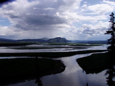
Everywhere you looked there were beautiful waterfalls pouring down into the river and glaciers which looked like frozen lakes tilted and perched on the sides of the steep mountains.


On the last day, we paddled across a lake for a few miles. It was cloudy and I could hear what sounded like thunder in the distance. The sound grew louder as we continued downstream. Finally Scott told me that the thundering sound was coming from an enormous glacier a mile ahead. When we reached the glacier, we parked downstream and hiked up and watched iceburgs calving off the face of the glacier. As they fell, they would make a loud booming sound, and sometimes form huge waves. One wave was so big that it picked up our rafts and moved them 10 feet up the bank. It was a strange feeling to watch skyscraper size chunks of ice suddenly break off and crash down into the river. It was an amazing experience, another simple life adventure coming to an end.